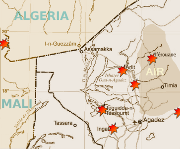
Photo: Map showing areas of Niger affected by uranium mining and aquifer depletion.
Photo credit: Targuinca
All of the areas on this map have been the traditional homeland of the Tuaregs for hundreds of years.
The blue area denotes the Agadez Aquifer (Grès d'Agadez) water table (groundwater).
The Azawagh Valley, an immense drainage basin where Tuaregs pasture their herds in the summer, and where many Tuaregs currently live, extends over most of this map except for the Air Mountains (in orange) and the areas south of Agadez. Much of the Agadez Aquifer is also part of the Azawagh Valley.
The dark purple lines denote areas where the government of Niger has awarded uranium permits.
The light purple lines denote areas where more permits might be awarded because they may have uranium.
The orange-brown area is the Air Mountain range.
The yellow areas are sandy areas and dune beds outside the aquifer zone, where many nomads also currently live. Wells (small circles) are distributed throughout.
The dark purple square near Arlit shows the location of Areva uranium mines for the past 40 years.
Paved roads are denoted by darker black lines; the other lines are dirt roads and tracks.
Why are Tuaregs in Niger concerned about uranium mining in their areas?
Tuaregs in Niger are concerned about the uranium mining in the areas where they live because it affects them in several significant ways.
The uranium companies exclude the impoverished local Tuareg people from employment opportunities in the mining industry, but even more importantly:
(1) uranium mining produces cancer-causing radioactive waste, including radon-infused gas and dust that pervades the groundwater ("aquifer") that Tuaregs drink, as well as the seasonal pasture lands where Tuaregs herd their livestock; and
(2) uranium mining makes extensive use of groundwater to process the uranium, depleting the aquifers, resulting in a low water table, dry wells, and a severe shortage of drinking water for both people and livestock.
(3) uranium mining poses an acute threat to the Tuareg way of life; within the next two decades they will no longer be able to survive in their homeland due to radioactive pollution and aquifer depletion.
Water scarcity is a critical factor for the survival of livestock-herding nomads in the desert environment, and in just the past few decades, the uranium industry has dramatically hastened the critical point at which the Tuaregs will no longer be able to survive in their homeland because of radioactive pollution and the depletion of water aquifers caused by the uranium industry.
Where do the Tuaregs live, and how do they nomadize?
Map, showing where the Tuaregs live in the central Sahara, with the Azawagh Valley marked: (Air-Voyages-Niger)
http://www.air-voyages-niger.com/Air%20medias/Map-touareg.jpg
Map, showing network of river-beds in the Azawagh Valley: http://italy.indymedia.org/uploads/2005/07/niger-map.jpg (Indy Media)
Peoples living in the northern and central Sahara have been engaged in livestock herding for thousands of years. Nine thousand years ago, the Sahara was not a desert; it was green and relatively lush, with forests and grasslands spreading across the top third of Africa, from the Atlantic to the Red Sea. The Sahara is as large as the United States, and is shared by eleven African countries.
Farming and pastoralism developed in the Sahara by around 8,000 years ago -- not long after it emerged in the Middle East about 10,000 years ago. Radiocarbon dates reveal that inhabitants of the central Sahara were already expert at managing wild Barbary sheep as early as 8000-8900 years ago (Hull 1998:84), and in the Adrar Bous and Arlit (Azawagh Valley) areas (Niger) by 5000-6000 years ago (Hull 1998:88). Sheep and goats seem to have been the main herds in early times. Starting about 7000 years ago, cattle were raised in some parts of the central Sahara. Many early (difficult to date) rock carvings and paintings display strong symbolic connections with livestock. Some sites suggest that local transhumance patterns (movement from a dry-season home area to a summer-season pasture area) were well-established thousands of years ago.
As a result of global warming, the Sahara began the slow process of transformation from well-watered woodland savannah to sparsely-watered desert at the beginning of the Holocene around 10,000 years ago, accelerated around 8,000 years ago with the introduction of farming, and wound into high-gear around 5,000 years ago, making it increasingly difficult over the next few thousand years to raise cattle in the Sahara.
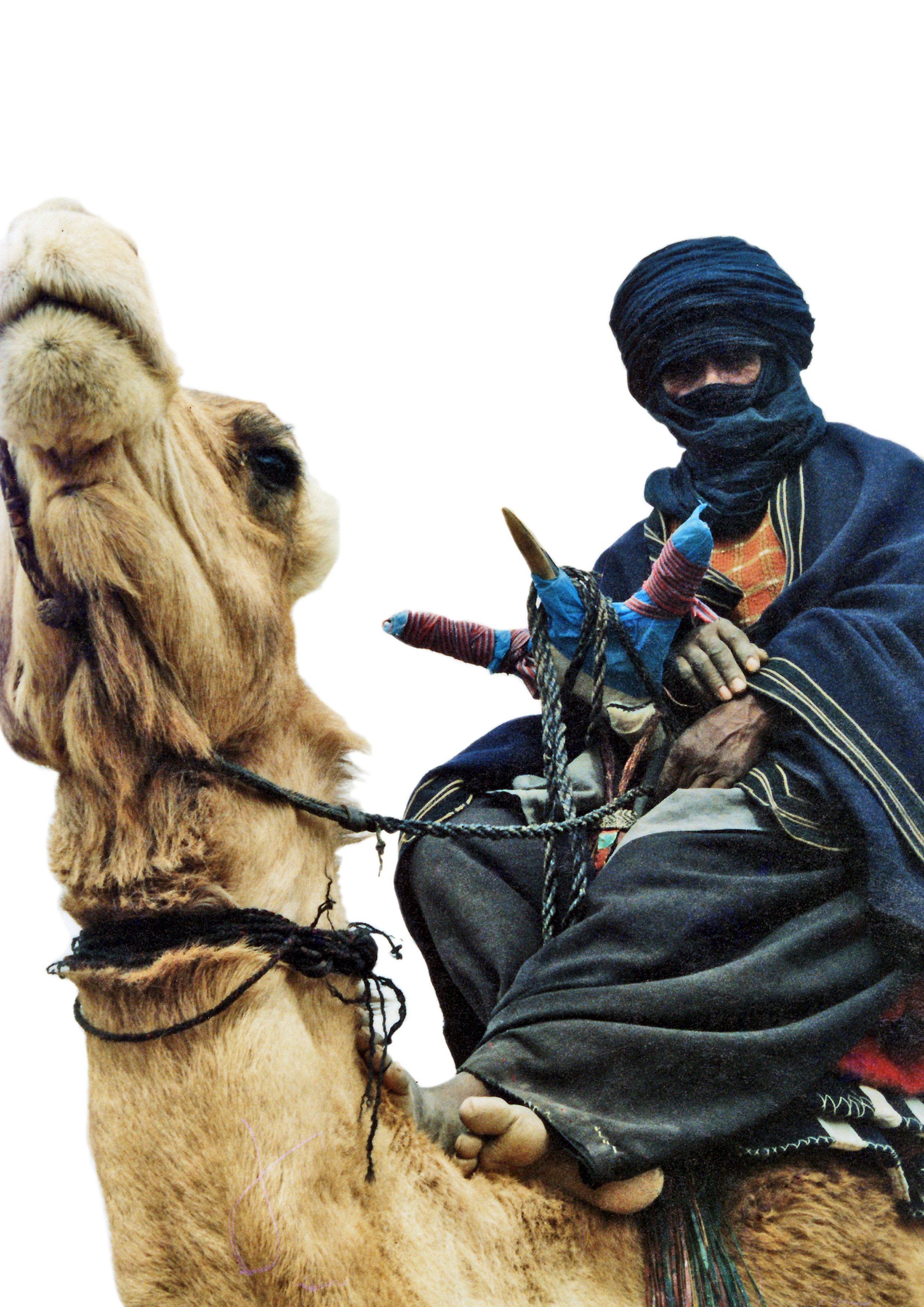
By about 2,000 years ago, the ancestors of Tuaregs in the northern Sahara had adopted the camel as a means of transport and major milk producer in lieu of cattle, and with the drying of the Sahara, gradually migrated further and further south, into the Ifoghas (Mali), Ahaggar (Algeria), and Air (Niger) mountain regions where there is greater pasture and water availability, enhanced by the Azawagh Valley drainage system which produces abundant rainy-season pasture.
Tuaregs today raise camels and goats; they also keep sheep, and some Tuaregs keep cows, as well. Cows and sheep are grazers (depend on ground-vegetation, grass), whereas goats and camels are browsers (they can reach up and eat higher vegetation such as leaves on trees and bushes). Cows and sheep are the first to go in a drought, since they depend on grass; camels and goats can survive a drought better, because they can eat leaves on trees and bushes.
In Niger, Tuaregs live in the "northern" part of the country, most of which is north of the 100 mm isohyet -- an artificial line that delimits the areas of very low annual rainfall, less than 100 millimeters throughout the year, that defines the Sahara (some scientists include areas as far south as the 150 mm isohyet in the Sahara, or even as far south as the 200 mm isohyet). By contrast, the area south of the Sahara called the Sahel has rainfall up to 800 mm per year. The Sahel is a transition area between the Sahara in the northern third of Africa, and the African savannahs to the south of the Sahara.
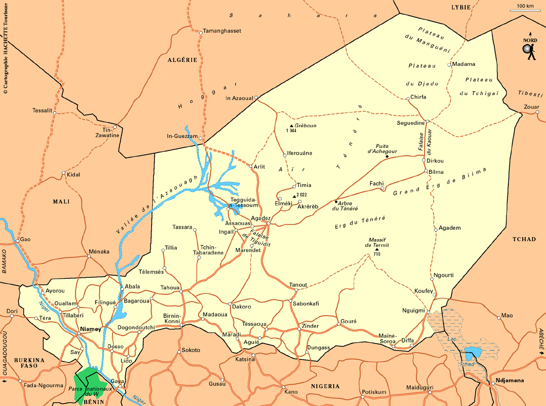
A major geographic feature of "the North" in Niger is the vast Azawagh Valley (Eghazer, "basin"). It is an immense drainage system extending from the Air Mountains, west of Agadez, north of In Gall, encompassing Arlit, all the way north to the Algeria-Niger border, and west, toward the Mali-Niger border. All of the uranium mines are in the center of this enormous region.
The Azawagh Valley produces seasonal grasses and plants and standing ponds of water with a high mineral ("salt") content that is nourishing for livestock. For hundreds of years it has been the practice of many Tuareg groups in Niger to move their herds to the Azawagh Valley from July to September during the summer transhumance, in order to take advantage of the abundance of vegetation there to feed their flocks during the rainy summer months.
During the rainy season, the main source of drinking water for people and animals are the temporary ponds that collect rainwater. After the seasonal vegetation there is exhausted in September, Tuareg families move back to their "home well area" at a distance from the Azawagh Valley, and slowly circulate with their herds during the nine-month dry season around a well to which their extended family has rights.
During the dry season, the main source of water for people and animals are the home wells, and water availability depends on the level of the underground water table and associated "aquifers" (underground water). Toward the end of the dry season, in April, May and June, the dry pasture around home wells begins to run out, the water table becomes low, and Tuaregs anxiously await the return of the rainy season so that they can move their herds to the Azawagh Valley and nourish them.
Tuareg dairy herders normally manage their herds so that camels give birth during the rainy season, when there will be plenty of pasture for lactating camels to sustain their offspring. The success of Tuareg dairy pastoralism in Niger depends on this complex cycle of transhumance, making use of the seasonal water and pasture supplies in the Azawagh Valley.
In the Sahara, rainfall is erratic and unpredictable, but Tuaregs have developed extensive patterns of pasture-sharing and well-calculated nomadic movements to maximize the available pasture and water in the Sahara. They have been able to survive in this hostile environment for hundreds of years, as a result of carefully-planned use of the available environment.
The Azawagh Valley and its seasonal mineral-enriched rainfall-water and pasture availability are key to Tuareg survival. But so is the water from wells, which comes from deep underground aquifers.
The ecological balance of water availability and herd management is fragile, and the uranium mining activities are steadily undermining the ability of the Tuareg people to making a living in their homeland. Within 20 years, groundwater sources will be exhausted through steady depletion caused by the uranium exploitation process, and the Tuaregs will not be able to survive the nine-month dry season which depends largely on the availability of (safe and abundant) groundwater to sustain people and herds for most of the year. Moreover, the water and land of the Azawagh Valley is being polluted by the uranium exploitation process, putting people and animals increasingly at risk for illness, cancer, stillbirths, and genetic defects.
Why does uranium mining deplete the groundwater?
Copious amounts of water are used in a variety of ways in the process of extracting uranium ore from the earth and processing it into convenient lumps of "yellowcake."
With "open-pit mining" techniques (conventional mining), the soil and rock ("overburden") on top of the underlying uranium-laden rock is removed by blasting and drilling, and water is extensively sprayed to suppress airborne particles, to reduce the workers' exposure to inhalation of radioactive dust. With "underground mining" techniques, shafts and tunnels are dug into the ground, and water seeps in and becomes perfused with radioactive and toxic waste. This is the most expensive method, because of the associated cost of blasting, drilling, digging and hauling, and because it is a lot slower.
With " leaching" techniques, liquids (solutions that combine caustic acids with water from wells that tap underground aquifers) are pumped into "injection wells" placed on one side of the uranium deposit, forced through the deposit, and then sucked up through "recovery wells" on the other side of the deposit, and thus leach out the uranium which emerges mixed with the large amounts of water pumped through the deposit. The large amounts of waste liquids must then be dumped somewhere, and they seep into the groundwater. This type of uranium extraction is the only type of uranium mining currently practiced in the U.S., and in the U.S. it is accompanied by environmental impact studies because the ground water can be affected adversely. This type of extraction is also the one most widely preferred, because it is the cheapest -- no extensive digging of volumes of overburden. Also, uranium companies get their uranium a lot faster this way.
What are the risks of uranium mining?
Uranium ore emits radon gas. During the 1950s in the U.S., after large deposits of uranium were discovered on Navajo reservations, mining companies hired a lot of Navajo Native Americans to work in the mines. Many Navajo miners developed small cell carcinoma as a result. Uranium mining also releases radioactive dust into the air and across the land. Uranium mining waste products from both conventional mining and from "leaching" procedures pose a great risk to people, animals and plants, through the pollution of aquifers -- the groundwater that seeps into wells, where people get their water for drinking and for watering livestock and gardens.
Where are the uranium mines in Niger?
For forty years, the French mining company Areva has been exploiting uranium around Arlit. Recently, the government of Niger issued mining permits to China, to explore for uranium and establish mines around Teguidda n-Tesumt and In Gall, south of Arlit. Numerous additional permits have been awarded to India, Britain, the U.S., Canada, Australia and others for uranium exploration from the area around Agadez, to the west of In Gall, and in all of the areas north to the border with Algeria. Nearly all of these areas are right in the middle of the great Azawagh Valley which is key to the survival of most of the Tuareg people in Niger.
Where are the aquifers that are affected by the mining industry?
The Agadez Aquifer (Grès d'Agadez), the major water table (nappe in French, groundwater, aquifer) in northern Niger, extends throughout the area where uranium mining permits have been awarded, from the Falaise de Teguidit (south of In Gall and Agadez), to Agadez, all along the western Air Mountains, up to Arlit, and west to In Abangharit and Mabrouk. This is an enormous area, one that has been key to Tuareg pastoral nomadism for hundreds of years. This vast aquifer, which represents clean water collected in the ground over hundreds of thousands of years, is being depleted and polluted by the uranium mining companies in order to extract uranium that will be used to produce electricity and nuclear weapons in richer nations of the world. In order to gain some perspective on the enormity of the problem, please refer to the map below, which is a .pdf file accessed on the Internet:
Map showing the affected aquifer regions in Niger:
http://www.targuinca.org/documents/carte-nappe-concessions-uranium.pdf
Download a 53-page report prepared by Tchinaghen on the situation, "The Uranium Malediction: North-Niger, Victim of Its Riches"
http://tchinaforum.free.fr/DossierTchinaghen.pdf
Issouf ag Maha's organization, Tchinaghen: http://www.tchinaghen.org/article-15807934.html
Other sources:
Hull, Augustin F. C.
1998 The Dawn of African Pastoralisms: An Introductory Note. Journal of Anthropological Archaeology 17(2):81-96, December 1998.


